
How a Braxton Property Search Works
The WV Property Assessment Search is the fullest tool for a Braxton property search. Its Basic tab accepts County, District, Full Parcel ID, Owner Name, Map Number, Street Name, Parcel, Sub-Parcel, Property Class, Tax Class, and Land Use. The Appraisal/Sales and Advanced tabs go further. They filter by value, acreage, sale date and price, mailing address, deed reference, legal description, flood hazard, and building characteristics. No field is required on the form. Fill in only what you need to narrow the results.
- Set County to Braxton and enter the Street Name, an owner keyword, or the known parcel components. A street search can return several properties along the same road.
- Open a likely result and note Owner, Physical Address, Mailing Address, District, Full Parcel ID, deed reference, and legal description.
- Use the full parcel ID or owner name to match the assessment card to the map and the recorded deed.
- Check a tax balance with the Sheriff Tax Office and use the viewer for map context; the assessment result is not a paid tax receipt.
- If the online result is incomplete, ask the custodian for the record or request a specific inspection under WV FOIA.
Which Braxton Search Fields Fit the Record
The tabs matter. Each one answers a different kind of question. Basic fields suit a known owner, street, district, or parcel number. Appraisal/Sales narrows a larger set by estimated value. It also filters by deeded or calculated acres, or a recorded sale range. Reach for Advanced when you already hold an old deed reference, a rural mailing address, a building year, or a flood detail. You need the parcel that matches it.
| Mode | Fields captured | Good use |
|---|---|---|
| Basic | County, District, Full Parcel ID, Owner Name, Map Number, Street Name, Parcel, Sub-Parcel, Property Class, Tax Class, Land Use | Find one card from a name, street, or parcel key. |
| Appraisal/Sales | Land, building, total appraisal; calculated and deeded acres; sale dates and price | Limit a search to a range, then compare similar parcels. |
| Advanced | Flood Hazard, Mailing Address, Deed Book, Page, Legal Description, building year, structure count, and area | Resolve older descriptions or a rural mailing label. |
The WV assessment search form displays these controls directly. Options and output may shift as the statewide data is refreshed.
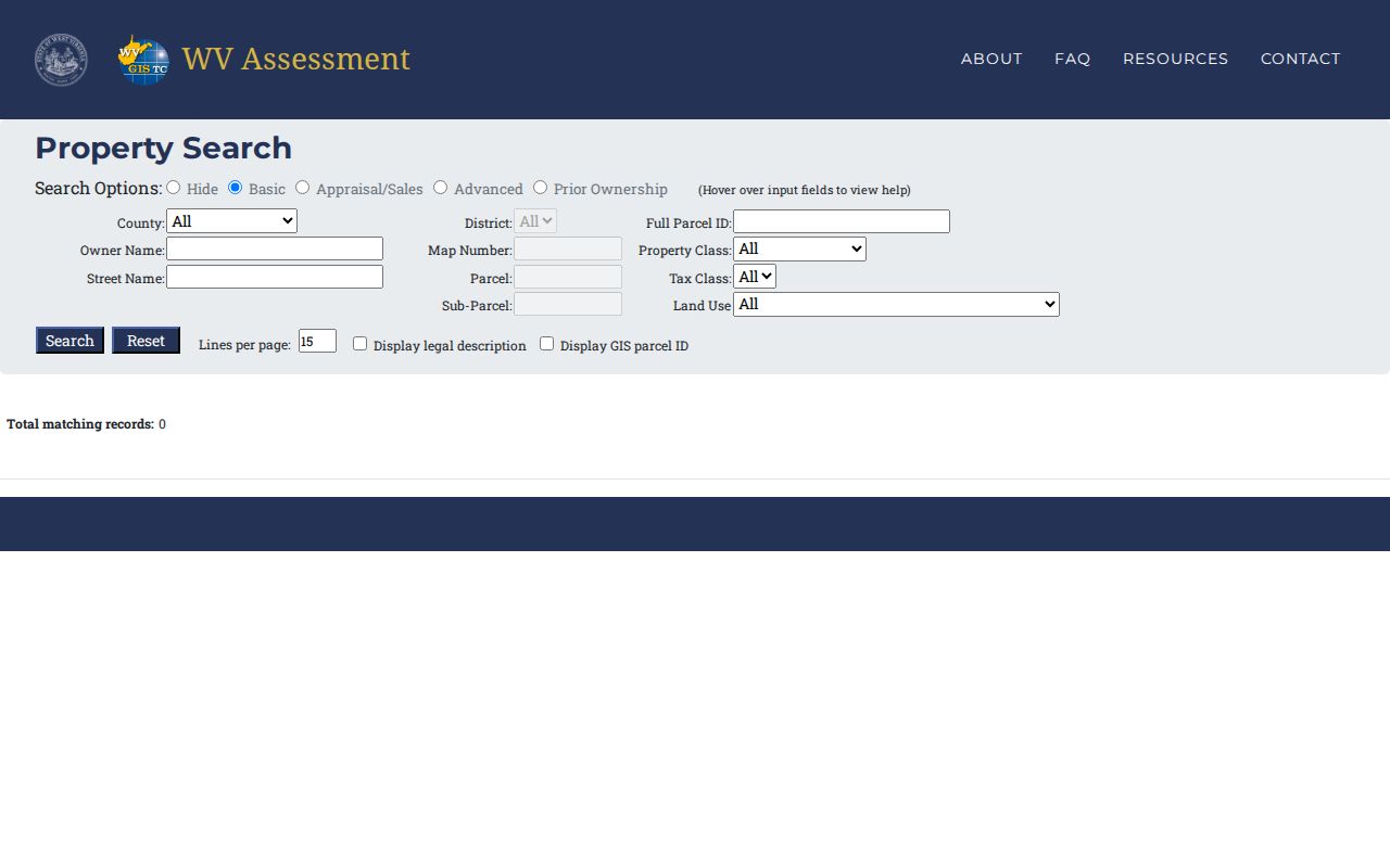
Start with one strong key. Add more filters only if too many Braxton results remain.
Searching Braxton by Street Name
The assessment form offers a Street Name field. There is no separate house-number box. That makes it handy for finding a block, a road, or a run of rural parcels, though it can return more than one tax card. Try a short street stem and a few spelling variants. An older deed may describe a house by a road, route, community, or stream name, so the modern postal label is not always the only match.
On the viewer or card, compare Physical Address, E-911 Address, Community, and Mailing Address. Each label serves a different purpose. A mailing address can belong to an out-of-county owner of record or an entity. The E-911 field supports emergency response. Neither changes the deed's legal description. For edge parcels, lean on district and tax class as clues rather than reading a town name as proof of municipal location.
Searching Braxton by Owner Name
Owner Name searches the assessment roll. It is the natural way to list every tax card tied to a person or company. The portal's rules for partial matching and punctuation are not published. Try the surname alone, initials, any known entity name, and a version stripped of punctuation. Inspect the results before concluding a parcel is missing.
Trusts, LLCs, estates, and shortened names can defeat a simple match. A deceased owner's card may linger while an estate transfer is pending. A company may use its registered name rather than the building's familiar one. The Secretary of State's basic search takes business-name keywords. The percent sign serves as a wildcard. Use its organization record to identify a related entity. Then confirm the actual conveyance in the County Clerk's deed index.
What a Braxton Property Record Shows
A Braxton assessment result blends tax-roll identity with property and building detail. Treat it as a lead to the deed, not a substitute for it. A sample statewide detail card for a Gassaway parcel shows a mailing address, the District 4 - Gassaway Corp label, physical address, property owner, building information, cost values, and appraised values. Its building panel can list year built, stories, architectural style, exterior wall, basement type, floor area, and building value.
| Owner and district | Owner name and the tax district or community attached to the card. |
|---|---|
| Physical and mailing address | Property location and the separate address used for tax mail. |
| Parcel identifiers | Full Parcel ID plus a GIS parcel ID used by the viewer. |
| Building card | Year, stories, style, exterior, basement, floor area, and building value when shown. |
| Appraised values | Land, building, and total values for the assessment record. |
| Legal description and deed reference | Recorded land wording and a book/page cross-reference where present. |
The sample's last-sale consideration is not shown. For assessment data use the Appraisal/Sales search. For the legal instrument use the recorded conveyance. A card cannot prove a deed is the latest filing. It also cannot reveal every lien release or settle a survey line. The sample parcel detail shown below illustrates field labels, not the property's present status.
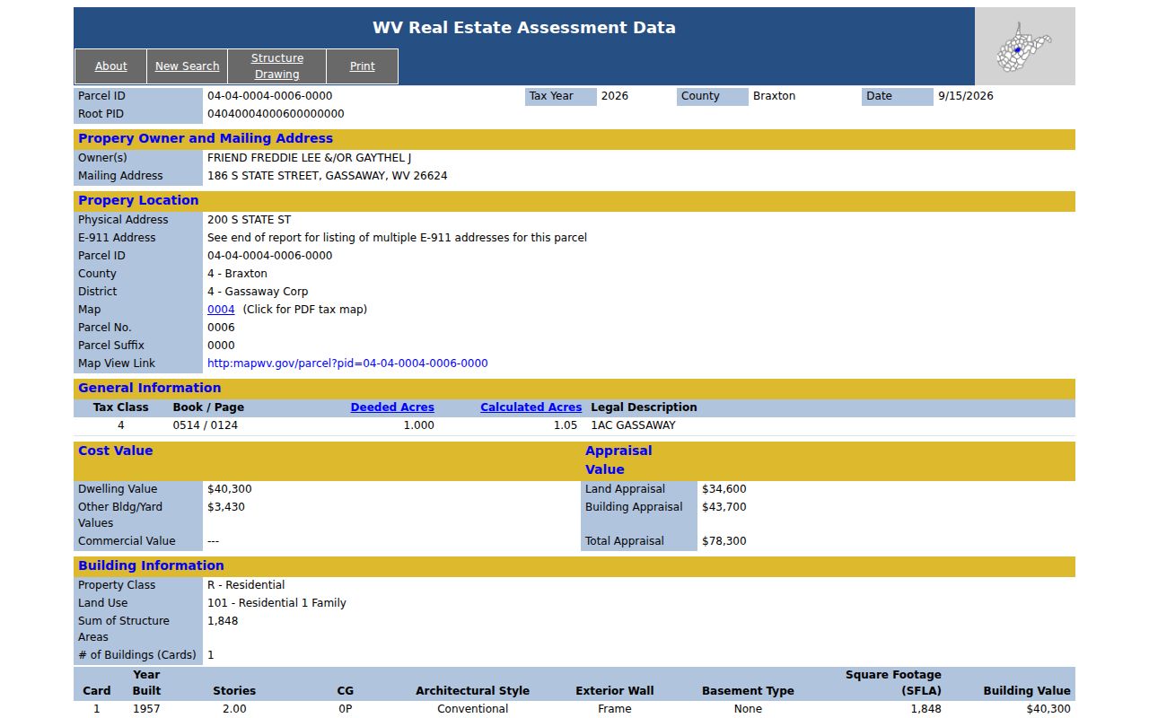
Read the field names as an inventory. Verify any live parcel through the official portal.
Search Braxton by Address, Owner, or Parcel
Choose the key least likely to have changed. An address is easy to remember. But it can shift with a town, route, or E-911 label. An owner name can surface several holdings at once. Though it may be abbreviated or hidden inside an entity. Once confirmed, the parcel ID is the strongest match of all. West Virginia IDs use six components. These are county code, district, map, parcel prefix, parcel suffix, and special ID. The GIS ID leaves off the special ID. Some system formats also drop the county code.
| Search Key | Best For | Where It Works | Watch Out |
|---|---|---|---|
| Street or address | Find a location or a block of parcels | Assessor Street Name and viewer Address | Town, E-911, community, and mail labels can differ. |
| Owner name | Find cards associated with a person or entity | Assessor roll and Secretary of State for entities | Aliases, punctuation, estates, and trusts can split results. |
| Parcel ID | Carry one parcel between records | Assessor, detail card, and WV Property Viewer | Keep full and GIS forms; do not guess a Braxton code. |
Not a title search. A Braxton property search returns public assessment and map information, not a guarantee of clear title. Confirm ownership and recorded interests with the County Clerk or a title professional.
Braxton Parcel Numbers Tie the Searches Together
A parcel ID works as a structured key. It is not just a map label. The statewide system builds each identifier from a county component, a district, a map number, a parcel prefix, a parcel suffix, and a special ID. A GIS ID drops the special ID. The CAMA/IAS form may skip the county component. Braxton publishes no roster of parcel-prefix ranges or district-to-map pairings, so never borrow a number pattern from another county.
Copy the full identifier from the assessment result. Then check it against the parcel viewer and the deed reference. If a portal chokes on punctuation or a shorter form, use the labeled components rather than guessing. Remember that a split, subdivision, or new boundary can change the map key while the street name stays the same. For reading geometry and recorded plats, see the Braxton parcel map guidance.
A Braxton Search Can Lag a Recent Closing
Statewide assessment data refreshes once a year. The refresh brings new tax information. The Property Viewer issues a warning of its own. A simple ownership change may not reach the displayed roll right away. New parcel line work takes even longer. State guidance covers transfers with new parcel lines. Those during the July-to-June period should be submitted by February 1 of the following calendar year. If the geometry still looks stale after two years, call the local assessor.
For the most recent owner of record, pull the deed. Use the assessment card first to pin down the legal description and prior grantee. A new owner can be absent from the web card. This can happen even after a deed is recorded. The online Braxton land-record directory states no index or image cutoff. Ask the County Clerk when a recent instrument or an older volume does not surface.
Braxton Search Fallbacks When a Portal Stops
The assessment application is free and open without a login. Still, not every land record lives online. The County Clerk serves as recorder and accepts deeds, liens, releases, plats, assignments, affidavits, and foreclosure trustee reports. The directory lists those document classes but shows no real index fields and no image depth. Ask the Clerk for a specific party, parcel, instrument, and year rather than assuming the statewide card holds a deed image.
West Virginia FOIA allows a reasonably specific inspection or copy request for public records held by a county or town. Ask each office about its preferred procedure. Braxton deed copy prices and archived index access are not published, so confirm them directly. Tax bills belong to the Sheriff Tax Office. Legal disputes belong in the court system. No single office's search replaces the next custodian's records.
Braxton Search Notes Keep Record Fields Together
A result could match more than one parcel. Save a short note before switching tools. Record the search term, the date checked, the assessment year, the district, the complete parcel ID, the GIS parcel ID, the owner field, and the mailing and physical addresses. Also note the legal description and the deed book and page when shown. That habit catches the moment a map opens a related but different tax account.
Keep the original value beside any later correction from an office. A street spelling, entity name, or mailing address can shift without touching the land description. When you contact the Assessor or Clerk, give the parcel ID and the one field needing explanation. Do not request every record at once. The saved details also smooth a follow-up after the annual assessment refresh changes the result.